Map
Creator of the Map: @RadharaniBhattacarya
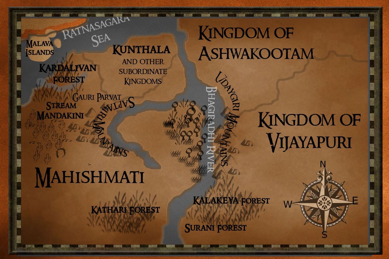
This is how a layout of Mahishmati and the neighboring kingdoms of Ashwakootam and Vijayapuri looks. Other prominent geographical features of Mahishmati that are relevant to this particular story have also been earmarked in this map.
Some of these details regarding the topography of Mahishmati and its borders come in Baahubali-2 during the Shapath (Oath) scene of Bhallaladeva's coronation. The rest of these details of geography and topography are my own imagination.
"With the Udayagiri Mountains as the eastern borders, the Malava Islands as its western borders, hemmed in by Kunthala and the other subordinate kingdoms to its north, and with the dense and fierce forests of Kathari, Surani and Kalakeya to the south stands the strong and mighty kingdom of Mahishmati!" These are the details Baahubali 2 gives.
The additions I have made for the sake of this story are the Sapthagiri Mountains which intersect the eastern and western parts of Mahishmati. One of the peaks in this mountain range is the looming Gauri Parvat on which the sacred and exhalted shrine of Amma Gauri is located.
It is the very same volcanic mountain where the volcanic stones of Gauri Kant which play an important role in enhancing the military power of Mahishmati are found. This particular idea was taken from Anand Neelakantan's The Rise of Sivagami which is a prequel to Baahubali 1 and Baahubali 2.
Bhagiradhi River, the life-giving river or Jeeva Nadhi that flows across the kingdom. I saw the Hindi version of the movies first where in the Shiva song, the name Bhagiradhi comes very prominently in the lyrics with the waters of the river in its background. So I simply assumed that the name of the river was Bhagiradhi. Then I learnt later when I read the prequel novel, The Rise of Sivagami, that the name of this river is Mahishi.
But it is impossible to change that now as far as my story is concerned. So for this story set in the world of Mahishmati, this river will always be Bhagiradhi. In the map here, the big water body that flows across a majority of the landmass of Mahishmati and some of the subordinate kingdoms like Kunthala before flowing and emptying into the Ratnasagara Sea is the Bhagiradhi River.
The forest of Kardalivan near the western borders of the kingdom; the forest stream, Mandakini that flows across Kardalivan in bent and curvaceous paths; and finally, the kingdoms of Ashwakootam and Vijayapuri that lie aproximately to the north-east of the Udayagiri Mountains have all been invented and imagined for the sake of this story.
I haven't described much about the kingdoms of Ashwakootam or Vijayapuri that are situated to the east of Mahishmati and nothing at all about the land of Kalakeyas that extends to the south of Mahishmati. There will be a map later on in the story for this too. But for now, since it isn't relevant to what you are going to immediately read or have already read, there is absolutely no reason why I have to info-dump my readers.
@RadharaniBhattacarya has done a fantastic job in bringing my vision of the world of Mahishmati to life. She owes the credit for creating this map. What a thousand words cannot adequately convey, a single word says it all. Thanks a lot, Radha.
Bạn đang đọc truyện trên: Truyen247.Pro