88. Natural Wonders
I sort of gave up, I seriously had to google for the list of natural wonders and that is where I got lost, for it appears that there are a number of lists though the most common one seems to be that which lists the seven wonders. However, seriously, how did they arrive at that number? There are so many of them, I am unsure how they decided to pick seven. But then, we have to draw a line some where, so I too decided to pick seven, the seven that I found to be the most fascinating.
[Warning - the pictures are from the internet (I mention the article from which the same have been taken) and the descriptions are from Wiki/ net articles.]
Here they are, in no random order:
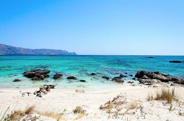
(PHOTO: Constantin Stanciu - from an article by Sophie Miura on mydomain.com)
Elafonisi beach has been voted several times as one of the most majestic beaches not only in Europe but also in the world. The area features exotic beauty: dunes, cedar trees, white lilies, black rocks, rare species of animals and birds that live there, blue waters and bright white sand. All these, make this beach really unique and Elafonisi holidays really popular! It is located in western Crete, 75 km southwest of Chania. Elafonisi is a small island at a distance of 200 meters from the shore. Between the island and the shore, there is a shallow lagoon of 1-meter depth at most.
The sand of Elafonisi beach is white, but in many places it is pinkish due to the thousands of broken seashells it contains.
_____________________________________________
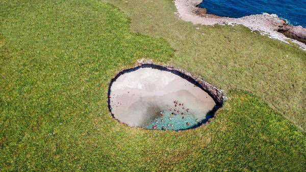
(Photo: Marietas Islands from an article by Sophie Miura on mydomain.com)
Barely visible from the sky, Islas Marietas' hidden beach is surrounded by huge rock walls that form a natural skylight. The surreal stretch of sand has a bizarre history: It's believed the secluded paradise was formed from an explosion when the area was used for military testing. Nature has now reclaimed the site, and the water is brimming with schools of fish as bright natural light streams from the opening above. The hidden beach can be reached by a short swim through a tunnel, which opens up into the stunning enclosure.
_____________________________________
(Photo: YYDB from an article by Sophie Miura on mydomain.com)
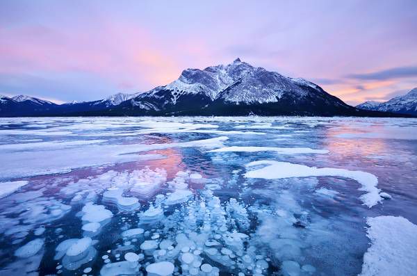
Abraham Lake was created in 1972, with the construction of the Bighorn Dam. The Government of Alberta sponsored a contest to name the lake in February 1972, during the final stages of construction of the Bighorn dam. Students across the province were asked to submit names taking into consideration "historical significance, prominent persons, geography and topography, and the value of the lake."It was named for Silas Abraham, an inhabitant of the Saskatchewan River valley in the nineteenth century.
Although man-made, the lake has the blue color of other glacial lakes in the Rocky Mountains, which is caused by rock flour as in other glacial lakes.
Pictures of Abraham Lake in the winter have become quite popular among internet users.This is due to a phenomenon that creates "frozen bubbles" under the ice. The decaying plants on the lake bed release methane gas, bubbles of which are trapped just below the surface as the lake begins to freeze. Abraham Lake has become a popular destination for photographers because of this
__________________________________________
The Matterhorn, Switzerland
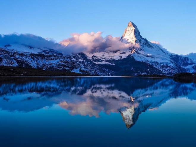
(Photo: from an article in the Independent)
The Matterhorn (German: Matterhorn [ˈmatərˌhɔrn]; Italian: Cervino [tʃerˈviːno]; French: Mont Cervin [mɔ̃ sɛʁvɛ̃]) is a mountain of the Alps, straddling the main watershed and border between Switzerland and Italy. It is a large, near-symmetrical pyramidal peak in the extended Monte Rosa area of the Pennine Alps, whose summit is 4,478 metres (14,692 ft) high, making it one of the highest summits in the Alps and Europe. The four steep faces, rising above the surrounding glaciers, face the four compass points and are split by the Hörnli, Furggen, Leone/Lion, and Zmutt ridges. The mountain overlooks the Swiss town of Zermatt, in the canton of Valais, to the north-east and the Italian town of Breuil-Cervinia in the Aosta Valley to the south. Just east of the Matterhorn is Theodul Pass, the main passage between the two valleys on its north and south sides, and a trade route since the Roman Era.
The Matterhorn, a classic Disney ride, is a rollercoaster modelled after this mountain.
______________________________________
Marble Caves, Chile
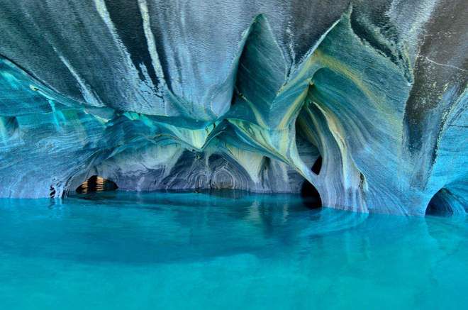
(Photo: from an article in the Independent)
Carved into the Patagonian Andes, the Cuevas de Mármol are located on a peninsula of solid marble bordering Lake General Carrera, a remote glacial lake that spans the Chile-Argentina border.
Formed by 6,000-plus years of waves washing up against calcium carbonate, the smooth, swirling blues of the cavern walls are a reflection of the lake's azure waters, which change in intensity and hue, depending on water levels and time of year.
_________________________________________
Pamukkale, Turkey
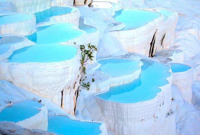
(Photo: from an article in the Independent)
Pamukkale, meaning "cotton castle" in Turkish, is a natural site in Denizli in southwestern Turkey. The area is famous for a carbonate mineral left by the flowing water. It is located in Turkey's Inner Aegean region, in the River Menderes valley, which has a temperate climate for most of the year.
The ancient Greco-Roman city of Hierapolis was built on top of the white "castle" which is in total about 2,700 metres (8,860 ft) long, 600 m (1,970 ft) wide and 160 m (525 ft) high. It can be seen from the hills on the opposite side of the valley in the town of Denizli, 20 km away.
Known as Pamukkale (Cotton Castle) or ancient Hierapolis (Holy City), this area has been drawing the weary to its thermal springs since the time of Classical antiquity.[1] The Turkish name refers to the surface of the shimmering, snow-white limestone, shaped over millennia by calcium-rich springs. Dripping slowly down the vast mountainside, mineral-rich waters foam and collect in terraces, spilling over cascades of stalactites into milky pools below. Legend has it that the formations are solidified cotton (the area's principal crop) that giants left out to dry.
________________________________________________
Aldabra:
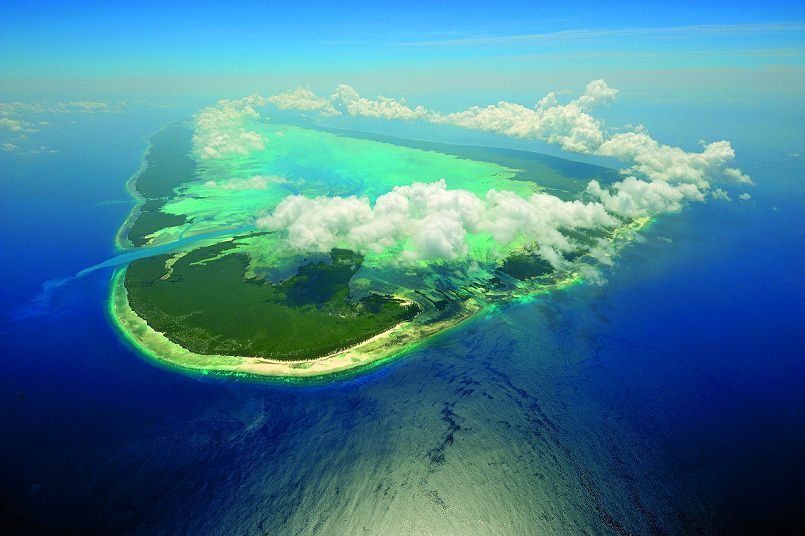
Aldabra is the world's second-largest coral atoll. It is situated in the Aldabra Group of islands in the Indian Ocean that are part of the Outer Islands of the Seychelles, with a distance of 1,120 km (700 mi) southwest of the capital, Victoria, on Mahé Island.
Extremely isolated, Aldabra is almost untouched by humans. Aldabra atoll is closer to the coast of Africa 630 km (390 mi) than to Mahé, and is in the most south westerly part of the Seychelles.
Aldabra atoll has, besides the four larger islands, some 40 smaller islands and rocks, all inside the lagoon, as well as a few very small islets at the West Channels between Grand Terre Island and Picard Islands, the largest of those being Îlot Magnan.
The earliest study of the flora and fauna, and also the geomorphological structure is dated to 1910. There are 307 species of animals and plants on Aldabra. Reptiles are the prominent terrestrial fauna. Sir David Attenborough called Aldabra "One of the wonders of the world", and it is also known as one of "crown jewels" of the Indian Ocean.
__________________________________________________
Word count 1330
And that concludes my list, as of today. By the way, did anyone notice what the common factor is, I noticed it only when I picked the sixth one, they are all blue...
Bạn đang đọc truyện trên: Truyen247.Pro